


According to the summary table attached to Decision No. 3627/QD-UBND dated October 28, 2026, by the People's Committee of central Thanh Hoa Province, the target for urban residential land (ODT) across the province by 2030 is 30,422.42 hectares, an increase of 17,240.93 hectares compared to 13,181.49 hectares planned in 2025.
During the same period, the target for commercial and service land is expected to increase from 1,548.10 hectares to 4,935.15 hectares, while land for public works construction will rise from 56,644.56 hectares to 72,858.32 hectares. These figures represent the scale of planned land, not the entire area to be invested in, constructed, or put into use immediately.
The appendix outlining the development orientation of the urban system for the period 2021-2030 mentions four existing inter-ward urban areas: Thanh Hoa, Sam Son, Bim Son, and Nghi Son; five new inter-commune urban areas: Hoang Hoa, Quang Xuong, Lam Son-Sao Vang, Thieu Hoa, and Tan Ninh; along with 17 new urban areas within a single commune. The appendix also identifies 12 urban areas located within communes.
This is an orientation for urban space, not a list of communes that will certainly be converted into wards. The ODT land target does not automatically change the type of administrative unit; the establishment of wards must be based on standards, conditions, and authorized decisions. The scope of urban planning in the appendix is also noted as tentative and may change when specific planning is developed.
Currently, Thanh Hoa has 166 commune-level administrative units, including 147 communes and 19 wards, according to the administrative unit arrangement resolution of 2025.
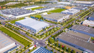
Industrial zone land target increases
The target for industrial zone land (SKK) by 2030 is allocated at 10,259.77 hectares, compared to the current status of 1,748.10 hectares in 2025, an increase of nearly 5.9 times. The list in the appendix includes zones already in the plan, zones with adjusted areas, and newly added industrial zones.
The areas mentioned in the list include Nghi Son, Bim Son, Lam Son-Sao Vang, Hoang Hoa, Ha Long, Thieu Hoa, and the western area of the province's administrative center. The appendix distinguishes between established zones, zones not yet established, and newly added zones; therefore, the planning list does not mean all industrial zones will be operational before 2030.
For industrial cluster land, the development orientation appendix records a total area of 4,204 hectares by 2030, comprising 89 industrial clusters. Meanwhile, the summary table allocating land targets records industrial cluster land (SKN) as 4,209.24 hectares. These two figures need to be cross-referenced with the official explanation and appendix before being used as the same target.
Commercial, service, and public land
The target for commercial and service land (TMD) allocated by 2030 is 4,935.15 hectares, an increase of 3,387.05 hectares compared to the current status in 2025. Among the development orientations mentioned are tourist, resort, coastal service, and eco-tourism areas such as Sam Son, Tien Trang, Ben En, Pu Luong, Nghi Son, and Am Tien.
Along with commercial and service land, the target for public land increases by more than 16,200 hectares. This group of land can serve common works and utilities, but the level of infrastructure improvement will depend on detailed planning, funding, and implementation progress in each area.
Land planning also needs to be considered alongside environmental protection requirements, transportation connectivity, water supply and drainage, schools, medical facilities, and green spaces. The allocation of new targets is the basis for implementing the next steps, not fully reflecting the quality of infrastructure after investment.
Need to assess implementation progress and effectiveness
The decision to allocate land specifies the province's development orientation for the period up to 2030. To assess the level of implementation, it is necessary to monitor the progress of detailed planning, land clearance, infrastructure investment, project attraction, and land utilization.
For the goal of expanding urban space, ODT land figures need to be placed alongside targets for population, urbanization rate, and service quality. For industrial development goals, it is necessary to distinguish between the area within the plan and the area that has been invested in and operated. Similarly, increasing commercial and service land only creates change when linked to economic activities and actual demand.
Thanh Hoa aims to become an industrial province by 2030 and strives to become a centrally governed city after 2030. Land targets are one of the planning bases for that goal; the results will be reflected in implementation progress, resource utilization efficiency, and the quality of life of the people.



 Google translate